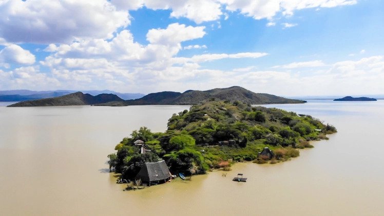
Crescent Island
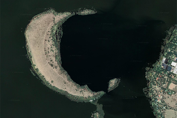
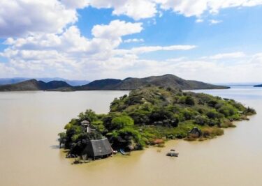
Image sourced from Autograph Safaris
Crescent Island is a geographical feature that has made quite a name for itself while remaining one of Lake Naivasha’s best-kept secrets. The island is the rim of an ancient volcano; part of it is submerged underwater hence the island’s crescent shape. The area is coated in ash owing to its volcanic nature.
Perhaps one of the most fascinating features of the land is the fact that over the years, it has oscillated between being an island and a peninsula depending on the lake’s water levels. When the water levels are high, the land that connects the island to the mainland is hidden by water and the island is only accessible by boat. When the water levels are low, this passage is visible, and it is possible to walk to the area from the mainland which becomes a peninsula. Although the area has been known as Crescent Island, it will continue to shift between being an island and a peninsula depending on water levels.
Cultivating Wildlife
In the 1800s, before the arrival of settlers, Maasai natives would often take their cattle over to the peninsula for grazing. They would use the exposed land that sat above the water. Though under the management of Kenya Wildlife Services, ownership of the island has passed down from one individual to the next. In the early 1900s, Crescent was the property of European Ernest Edward Hammer. He was also known as Bwana Tumbo and mainly used it to cultivate potatoes.
In the 1960s, Hammer put the property up for sale and it caught the eye of ornithologist Jean Hayes. She envisioned days of watching birds camped out in the peninsula’s canopied trees. So, her husband – journalist Charles Hayes – purchased the peninsula and set to work turning it into a wildlife sanctuary. In the realisation that animals were crossing over to the mainland using the walkway, Hayes purchased the Sanctuary Farm. This was the land across from the peninsula where animals like zebras and impalas would roam. Charles also fortified the walkway with a causeway to make it easier for animals to go between the peninsula and the mainland. He also did not completely abandon the farming legacy left by the Maasai and the previous owners. Hayes purchased ox, added vegetables and Jersey cows for milking.
In 1969, Hayes handed over the peninsula’s ownership to a consortium called Lake Naivasha Enterprises Limited. The peninsula began to garner interest as investors saw its natural beauty as a selling point. Film companies began to case the peninsula as the perfect venue for movies and ‘Living Free’ became the first of a few films to be set there.
On the Big Screen
To accommodate large film crews, a restaurant was built on the premises – in the shape of a crescent to complement the land’s unique shape. It came complete with waiters dressed to the nines and a well-stocked bar.
Crescent came to gain international prominence through a feature in the 1985 film ‘Out of Africa’. Its sweeping grandeur made audiences take notice. Using the walkway, additional animals like gnus, wildebeest and lions were taken to the peninsula to serve as the film’s backdrop.
A mere three years after its cinematic debut, Crescent Island was established. Increasing water levels completely covered the land connecting it to the mainland. For the first time ever, it was no longer a peninsula. The island was cut off entirely from the mainland. Animals that had been taken across the walkway to create the scenery of the popular film were trapped.
Not Always an Island
But this was not the last time that Crescent Island was a peninsula. With climate change, water levels were not as predictable as they were. Just six years after the island’s establishment, the walkway became visible. It remained that way until April 2020 when Lake Naivasha spilt over the land and made the island inaccessible by walking.
As such, Crescent Island is home to spectacular wildlife that roams its perimeter. From graceful dik-diks to long-legged giraffes and pushy buffalos, there is no shortage of wonderful sights to behold. And how these animals came to inhabit the island is as fascinating as it is unlikely.
The island has become a popular tourist destination over the years. It is now home to a variety of safari lodges and campsites that provide accommodation for visitors. Visitors can also enjoy a variety of activities on the island such as boat rides and bird watching.
Are you familiar with Crescent Island? Have you ever taken a tour of this unique Kenyan gem, or do you remember when it was a peninsula? Let us know in the comments!
2 Comments
It’s a very nice sanctuary with very cool hippos
Hi, thanks for the island history briefed above. I was there in December 2023. At the time, Mo`emba was our island guide, one of the island`s staff members. He is a Masai who is working to guide tourists in the island. He has told the island`s story with some differences in the details. One detail was that the big five were brought by the crew of the first film production in the seventies, a TV series by the name “born free”, along with gazells , wilder beest, water bucks and ostriches. When the production came to end, the crew removed the predators from the island and left the the other grazing animals alone where the lived in natural rich habitat. He told us that with a later lake water level drop the island gets connected to main land where more animals managed to migrate into the island. He also explained there is a water depth difference between the lake on the concave side which is much much deeper than the shallow depth on the convex side. and that the lake would drain its water through subterranian natural paths in its way to the Indian ocean close Mombasa. He has also explained the reason behind the dead trees along the island, and in fact along the lake shores. The reason as told is the marked rise of water level so that it invaded over the shores leading to the death of near by trees. The reason behind increased water level was two way, one is the closed business of protected farming along the mainland lake shores at the time of COVID 19 with diminished water consumption for farming, and the second reason was some tectonic plates movements that caused rising water levels at the time.
Thank you for providing the story of the island.